Discover New Zealand, Home of Middle Earth
Monday, Day 8. Haast turns out to be almost empty except for the holiday park which has locked showers. There is no one on duty for us to complain, so we head south along NH6 to Wanaka and Queenstown. With so few people around, there is no filling station open, so I coast most of the way from Haast Pass. We arrive in Wanaka with only fumes in the diesel tank, once again proving the old aviation adage that an engine failure usually occurs because the fuel tank is filled with air!
NH6 winds along lake Wanaka and Lake Hawea before reaching the Hawea Flat and Albert Town. We especially liked the clear mountain lake water, which, unfortunately, is rather low this time because of the recent lack of rain. The mountains in the background are of two distinct structures. The rounded ones are deposits of gravel, called "moraines," which consist of soil scooped up by the glacier which came down this valley and deposited when the glacier melted. The jagged mountains are the result of earlier tectonic activity.
We had planned to drive to Queenstown along the Cardrona River on the Crown Ridge Road, but we had been warned that driving the camper van there was not permitted. We found out later that it wasn't that hazardous, but by then it was too late. Stefanie thought this was an ideal spot to have her picture taken against the mountain backdrop with her new wool scarf, which she bought yesterday in Wakefield. In a country of 8 million sheep, you can get some very nice woolen things.
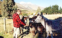
Next on the agenda was the Safari of the Rings tour, which took us out to the gold rush town of Arrowtown before turning west. There we met some donkeys whose ancestors had been pack animals for the regional prospectors. Our safari guide, "Stoney," knew that they would want to be fed, and came prepared. There was a mule 
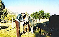
there, too, but he didn't seem very interested. Stefanie had to get a picture of herself petting the donkeys, which they obliged, but I think they expected a treat as payment for being in the picture.
We stayed on the road along Lake Wakatipu, with a beautiful view of the mountains, and passed some farms where we stopped to have a chat with some llamas. The Safari was well planned for the sightseer, but I wanted actually to set foot in the exact locations of things listed in Ian Brodie's LOTR Location Guidebook. Stoney pointed them out and talked about them as we drove by. As a result, whenever we stopped, I jumped out to find the location I was looking for to take a picture. Stoney was trying to keep to on his schedule, but was good-natured about it, even though I made him late getting back.
One of the places we visited was a red beech forest near Closeburn, which Stoney said was like (but not exactly the same place as) the entrance to Lothlorien where the remaining fellowship met Haldir. (Gimli breathed so loud they could have shot him in the dark!) This was also the area for some of the shots of Amon Hen, where the orcs killed Boromir and kidnapped Merry and Pippin. The location on the right is the general area where Gandalf leaves the Shire and heads for Gondor. The Location Guidebook is not very specific about the locations, and it would have helped to have GPS coordinates. If (when) I ever go back, I am going to retrace this route with someone from the film crew (or Stoney, if he's willing) and locate the exact vantage points involved.
Part of the Safari involved a stop for cookies, tea, coffee and fruitcake, which Stoney provided for us to snack on while he collected the money for the trip from all of us. The other people made disparaging remarks about the fruitcake, so I ate most of it. I had a New Zealand Discount Card, but I forgot about it, so I don't know if I would have received a discount for the trip or not. Stefanie thought this this would be another good place to take a picture, so I took one of her and we had one of our fellow travelers take one of the two of us.
The end of the safari was the Dart River around Glenorchy. This is the location of Isengard, the fortress of Saruman, and the central tower of Orthanc. Orthanc was composed of various sets and a giant model, but the scene was digitally imposed on the Dart River terrain. There's nothing left of Isengard now. (Of course, we know that the ents tore down the tower and buried the underground weapons factories in silt when they destroyed the dam and let the Dart River in.)
Click here to go to Day 9 * Click here to send us e-mail