Discover New Zealand, Home of Middle Earth
Friday, Day 12. We have finally spent a night in Wanaka, through which we passed Monday on our trip from Haast to Queenstown, and we wake up to fog on the mountains across the lake. We decided to find Cardrona Hotel, which, we are told, is very much like The Prancing Pony in Bree. We had to bypass it on the way from Queenstown because we had been warned not to take our camper van on the road, but from Wanaka it was very straight and wide.
Both the hotel and the village are old, dating from 1863, but the hotel looks much more modern than the inn where the hobbits stayed, and we didn't think we'd find any rangers there, even if it was open, which it wasn't. This little building housed the general store, post office, and telegraph office, and apparently a filling station later on. The sign outside the hotel recalls the time when New Zealanders still traded with pounds, shillings and pence.
Following Ian Brodie's guidebook, we headed in the direction my Garmin GPS12 said was the location of the view of the Great East Road with the digitally added ruins. Unfortunately, I had entered the longitude as E168 degrees 48.342 minutes instead of 58.342 minutes, so it was 8 kilometers closer than I thought it was. Part of that distance turned out to be the Treble Cone Ski Field, so we went charging up the mountain on a gravel road best left to goats.
When we got to the top of the mountain and there was still another 2 km to go, I figured something was wrong and discovered my error. The trip down made Stefanie nervous, as I left the Fiat in gear and let engine compression keep us at a safe speed. It made a lot of noise, which she didn't like at all. Once at the base of the mountain, we found the Great East Road (the photo on the left), but without the ruins I was not impressed. We saw some other formations which were much more spectacular, and made me wonder by what geological process they had been formed.
During the entire trip, I was looking for LOTR Middle Earth locations, not unlike the southerners who spend their free time poking around Civil War battlefields to find the exact spot where the damnyankees shot great, great, great Uncle Bubba. Stefanie was more interested in photographing the cute animals. Most of the time she could coax them to her, but these cows just stared at her and wouldn't budge. Finally she decided if they wouldn't get closer to her, she'd get closer to them. That's when she found out about the electric fence!
Coming back we took more pictures of the mountains around Lake Wanaka and Glendhu Bay. Again, the water was so clear it was hard to see what the ducks were sitting on except when they moved. We noted some very large fish in the water, but I couldn't tell what kind they were. I was surprised not to see anyone fishing; it seemed perfect weather for it. The Alps in the distance were seen in the film as Gandalf escaped from Orthanc on the back of Gwaihir, the lord of the eagles.
At lunch back in Wanaka I noted the excellent artwork on the signs, which I thought were blackboards with chalk markings. I was informed that they are made by a local signmaker, who includes permanent graphics designed so the things that change can be entered in chalk without looking like they were added on. The whole effect is very professional, with a nice "home made" touch.

The small population of New Zealand results in facilities and customs very much like the small Iowa towns of my childhood, where the few people in each little town had to rely on each other because wartime rationing didn't allow them to travel to the big city. Travel isn't a problem in New Zealand, but there aren't many big cities to travel to.

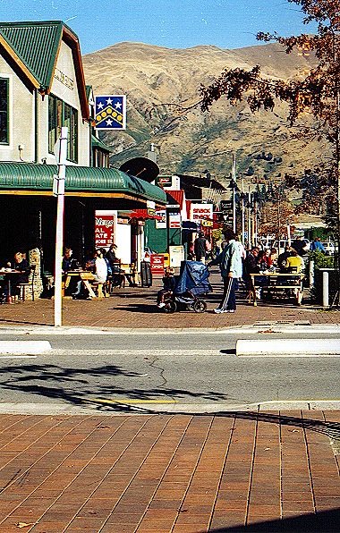
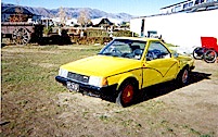
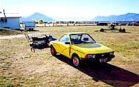
In the afternoon we visited the Transportation & Toy Museum just outside Wanaka. They have tens, perhaps hundreds of millions of dollars worth of cars, fire engines, dolls, and miscellaneous big kids' and little kids' toys. I decided not to try to take pictures, 
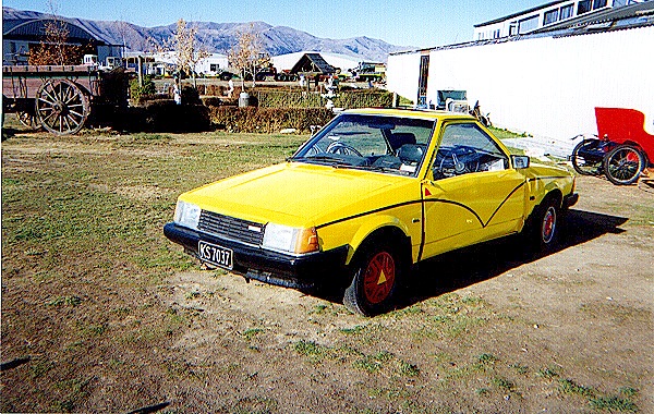
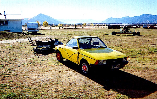
but to wait for the brochure when it is published. One vehicle I had to photograph was this "pushmepullyou." On one end it's a Mazda; on the other end it's a Ford. I can't tell if it's coming or going.
We finally left the McKenzie Basin and exit NH6 for NH8 for the next leg of our journey. We took a 6 km detour south to the general location of Arwen's flight among the pine trees to the Ford of Bruinen, carrying the wounded Frodo while she outran the Black Riders. I imagined that the Great East Road must have been fairly narrow in places, not unlike the side road we found, on the flat ground between the Weather Hills and the Hoarwell (Mitheithel) River.
The road crosses the Hoarwell before the place where the Fellowship met Arwen by The Last Bridge. I imagine the scene from the bridge must have looked something like this. Aragorn noted that the road ran along the Bruinen (Loudwater) for several miles. The area was partially wooded, and is not far from the place where the trolls threatened to cook and eat Bilbo and his companions until the sun came up and they all turned to stone. The stone trolls are seen in the film, but I couldn't find out exactly where the set location was.
The land around the Great East Road was fairly flat except for some local hills. I imagine that it looked very much like the terrain on our way to Methven. We were somewhat behind schedule, so it started getting dark and foggy as we approached Lake Pukaki and Lake Tekapo. Stefanie got an evening picture of one of the lakes when the fog lifted momentarily, but I don't know which one.
Click here to go to Day 13 * Click here to send us e-mail